Rocks tell stories. Sometimes the stories are obscure, enigmatic, even, and our interpretations are debatable. Other times, the stories are straightforward, unambiguous, incontrovertible. Once such story is written in the rocks along Kolob Terrace Road in Zion National Park. These pictures are from my trip there in May, 2016.
pic …0516 115948
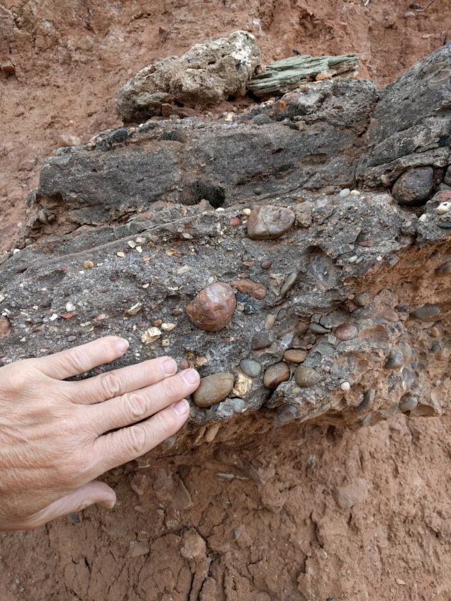
As I started up the valley there were stories begging to be read. The above photo shows evidence of five different “events.” In the foreground, filling the bottom half of the photo, we see a pile of sand and gravel piled against the bank in the background. In the center, there is a small exposure of fine-grained, thin-bedded rocks. Above them is a mess of cobbles and sand and mud with large black rocks in the upper part of the mess. A closer examination shows that this mess is actually two different layers–a lower layer without the basalt boulders, and an upper layer with the boulders. Each of these units–the sand pile, the thin red layers, the coarse layers, and the material at the top–was formed by distinct processes. The process that formed the thin horizontal layers in the dark red deposit could not also create the coarse deposit with the basalt boulders in it. Moving boulders takes a lot of energy. The basalt boulders came down the canyon in a massive flood that would have swept away everything in its path and jumbled everything it touched. That kind of torrent could not also form the rock-free layers of fine-grained mud. Laying down a flat, thin layer of mud requires slow-moving water. There is also an obvious order to some of the chapters of this story. The thin reddish layers had to be deposited before anything else in the picture. One obvious question raised by this picture: where did the basalt boulders come from? Most of the rock in that part of Utah is sandstone and related sedimentary rocks. Where did this volcanic stuff come from?
pic … 0516 121725. Lava flow
Just a mile or two up the road is this view. The rocky horizontal layer capping the light-colored slope in the center of the picture is a lava flow. The same flow is seen above the road where the road turns to the right. That’s the likely source of the basalt boulders. I have driven this road before and noticed the lava flow. I know that higher up the canyon, there are two or three cinder cones marking the source of the lava flow. I’m thinking the interesting part of this story is going to be the erosion around the lava flow. At the time of the lava flow, the canyon was only half as deep as it is today. After the lava flow came down that smaller, narrower canyon, the water continued cutting, creating wider, deeper canyons on both sides of the lava flow. I was looking for a good place to get a picture of this perched lava flow, sitting on top a ridge in the middle of the canyon when I got interrupted.
pic 0516 122317
What’s going on here? We see the lava flow on top. We see fine-grained layers on the bottom. But what’s that in the middle? It is another flood deposit. The flood apparently cut a channel in the fine-grained material and filled it with great chunks of rock along with mud and sand.
pic 0516 122411 Close up, flood deposit.
A closer look at the chunks of rock incorporated in this flood deposit. I call them “chunks” instead of “boulders” because they are so angular. They have not traveled very far or they would have been more rounded. When I looked even closer, I was even more surprised.
pic 0516 123743. Conglomerate.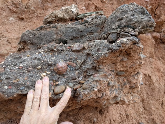
Conglomerate! The boulders are not basalt. In fact, in this layer there is no hint of basalt inclusions. This flood happened before lava was in the neighborhood. The basalt came later and buried the flood deposit. Where did this conglomerate come from? It looks like Shinarump, a layer of rock that lies below the Navajo Sandstone. Navajo Sandstone is the rock that makes up the famous cliffs of Zion NP. Shinarump is older and lower than the Navajo. The Shinarump has a lot of petrified wood in it, so I looked. Sure enough, just feet away I found a big piece of petrified wood in the matrix.
pic 0516 124341. Petrified wood in flood matrix.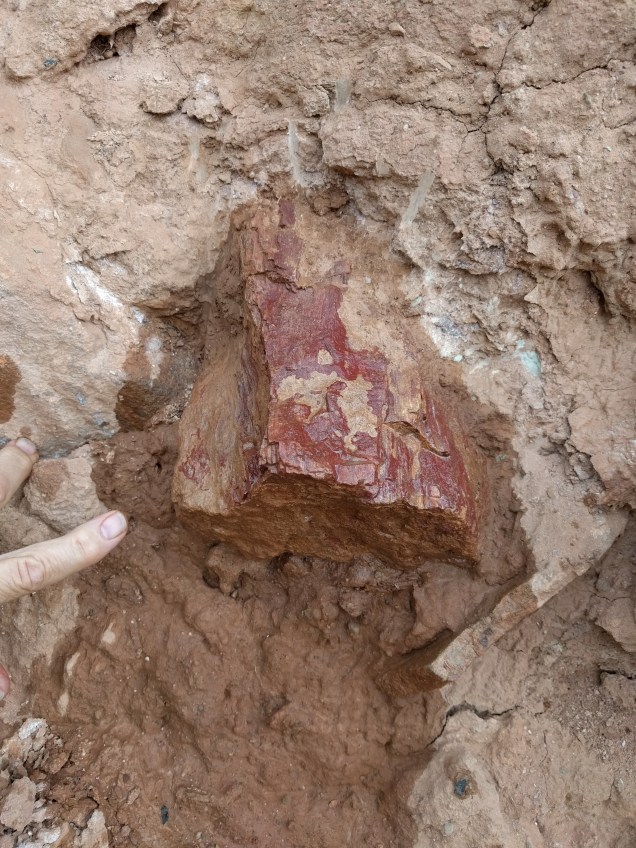
Studying this flood deposit added details to the story of the canyon. The canyon had to be cut down through both the Navajo Sandstone and the Shinarump before the lava flow happened. At the time of the flood that deposited these conglomerate blocks, the canyon was probably substantially narrower than it is now. The flood undercut the canyon wall below an outcrop of Shinarump conglomerate. Chunks of the Shinarump layer (and pieces of Navajo Sandstone above it) fell into the flood and were transported a short distance before the flood lost the energy require to transport boulders. The existence of chunks of sandstone in this flood deposit is further indication this material was not transported very far. Sandstone cannot survive very long in the rough and tumble world of violent floods.
pic 123959. Sandstone block inn flood deposit. 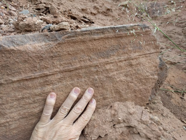
In the two photos below we see the right and left sides (looking upstream) of the lava flow hanging above the canyon. The horizontal layers farther to the right (in the first picture) and to the left (in the second picture) on the far sides of the canyon, are not lava, but layers of sedimentary rock. At this point the flow is less than a quarter mile wide with the canyon dropping hundreds of feet down on either side. From the air, the flow would appear to constrict and flow along the top of a ridge in the middle of a large canyon!
pic 0516 125038. Right side of lava flow.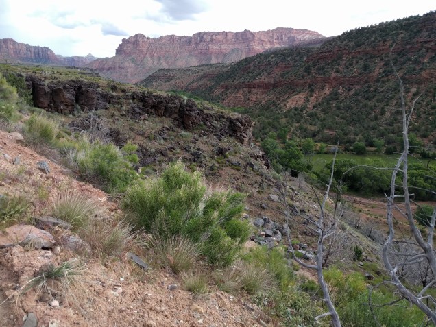
pic 125153. Left side of lava flow.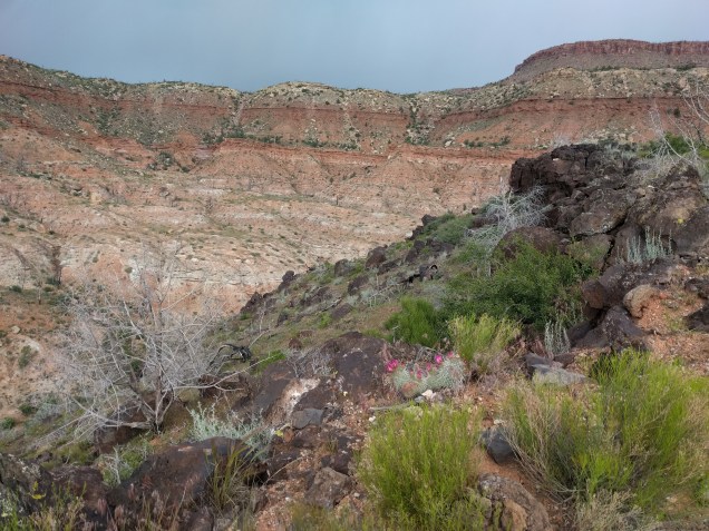
pic 141638. Lava, flood, in situ sedimentary layers.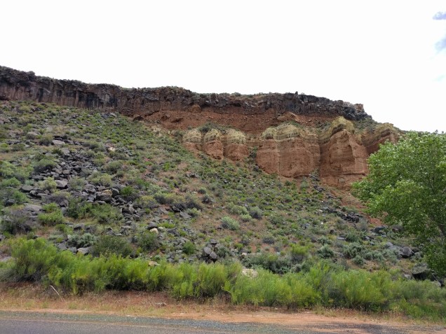
pic 141646. Close of upper flood deposit.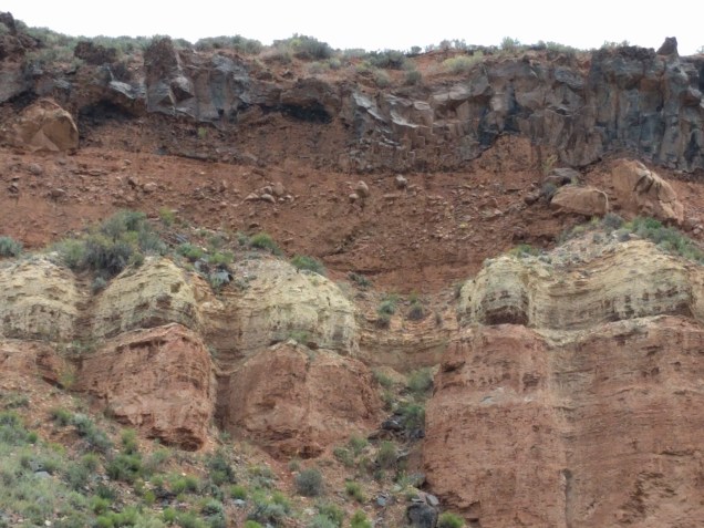
A view of the lava flow farther up canyon. Notice the flood deposit under the lava. This is a very different appearing deposit from the flood deposit previously mentioned. I don’t know if this is the same flood event, just farther upstream, or an entirely different flood event.
pic 0517 123311 Cinder cones
Cinder cones at the top of the canyon marking the source of the lava flow.
pic 0517 120121 Water-rounded basalt columns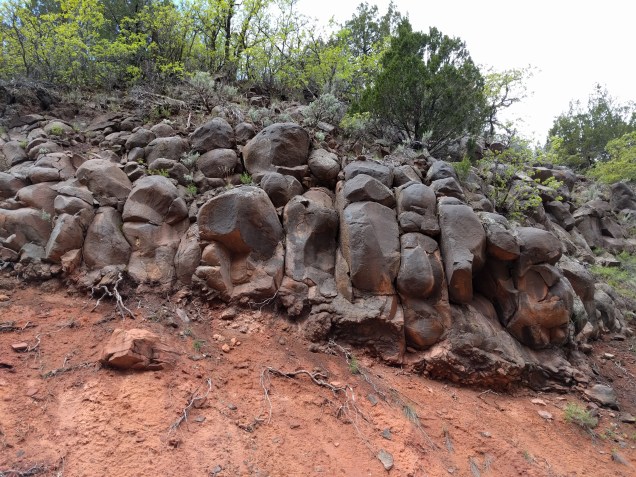
The water-rounded basalt columns in this photo are the edge of a lava flow that originated near the cinder cones pictured above. However, this flow traveled down a different canyon (into Hop Valley). Apparently as the water was cutting the canyon around the lava flow the flow of the water was concentrated on the lava at this point long enough to carve its signature into the rock. But that’s another story.
The moral of the story. First, there is no need of a moral for people like me. I’m fascinated by the stories written in the rocks, fascinated by all the details. I can get happily lost for days at a time deciphering the story written in a single canyon. But if you’re looking for a moral, here it is: rocks tell stories. We can read many of the small chapters in the story. If we are going to tell a grand, all-encompassing story about the rocks, that big story probably should incorporate the simple plots legible in the chapters.